


GA, UNITED STATES, March 3, 2025 /EINPresswire.com/ -- A new downscaling method has been developed to generate high-resolution surface soil moisture (SSM) data for mountainous regions. By integrating land surface temperature (LST) and vegetation index (VI) data, this innovative technique enhances the spatial resolution of coarse satellite-based SSM products, correcting for topographic effects and providing accurate, seamless SSM maps. This advancement is poised to revolutionize hydrological studies, drought monitoring, and climate change research.
Accurate monitoring of surface soil moisture (SSM) is critical for understanding water, carbon, and energy exchanges between land and atmosphere. Yet, satellite-based SSM products often suffer from coarse spatial resolutions, limiting their usefulness for localized studies. In mountainous regions, terrain complexity exacerbates this issue, as topography influences land surface temperature (LST), further complicating SSM estimation. To address these challenges, researchers have developed a new method to generate high-resolution SSM data that accounts for topographic variations.
A recent study (DOI: 10.34133/remotesensing.0437) published on February 20, 2025, in Journal of Remote Sensing introduces an innovative technique to downscale SSM data in mountainous areas. Conducted by the Institute of Mountain Hazards and Environment at the Chinese Academy of Sciences, this research solves the problem of accurately mapping SSM at high resolutions. The new method leverages LST and vegetation index (VI) data to enhance the spatial resolution of existing SSM products, creating seamless, high-resolution maps.
The study presents a novel downscaling technique that significantly improves the spatial resolution of SSM data in mountainous regions. By combining LST and VI data, the method produces 1 km resolution SSM maps from the original 25 km European Space Agency (ESA) Climate Change Initiative (CCI) SSM product. The innovation lies in its ability to correct for topographic effects on LST, improving both the accuracy and spatial continuity of the downscaled SSM data. This new technique outperforms existing methods in capturing the spatial heterogeneity and temporal dynamics of SSM.
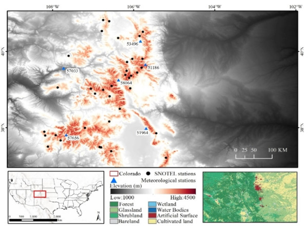
Conducted in Colorado, USA, the study combined the ESA CCI SSM product with MODIS LST and NDVI data. The downscaling method uses a self-adaptive calibration technique to estimate SSM coefficients via a moving window approach. Results demonstrated an average correlation coefficient of 0.47, RMSE of 0.103 m³/m³, and ubRMSE of 0.056 m³/m³ when validated against in-situ SNOTEL measurements. The downscaled data also showed strong spatial correlation with the SMAP-HydroBlocks SSM product, confirming its accuracy.
Dr. Wei Zhao (Institute of Mountain Hazards and Environment, Chinese Academy of Sciences), the lead author of the study, emphasized the significance of this new approach, stating, "This downscaling method represents a major advancement in accurately mapping soil moisture in complex terrains. By accounting for topographic effects on LST, we've created a more seamless and higher-resolution SSM product. This innovation holds great potential for transforming hydrological studies and climate research in mountainous regions."
The new technique has wide-ranging applications in hydrology, agriculture, and climate change research. It can be adapted to other satellite-based SSM products, providing high-resolution data globally. The method’s ability to generate more accurate soil moisture maps will enhance drought and flood prediction models and support sustainable water resource management efforts worldwide. This breakthrough paves the way for more precise monitoring of soil moisture dynamics in diverse environments, offering a powerful tool for addressing the challenges of climate change.
DOI
10.34133/remotesensing.0437
Original Source URL
https://spj.science.org/doi/10.34133/remotesensing.0437
Funding information
This work was supported by the National Natural Science Foundation of China (42222109 and 42071349), the National Key Research and Development Program of China (2020YFA0608702), the Key Program of the Chinese Academy of Sciences for International Cooperation (162GJHZ2023065MI), and the Science and Technology Research Program of Institute of Mountain Hazards and Environment, Chinese Academy of Sciences (IMHE-CXTD-02).
Lucy Wang
BioDesign Research
email us here
Legal Disclaimer:
EIN Presswire provides this news content "as is" without warranty of any kind. We do not accept any responsibility or liability for the accuracy, content, images, videos, licenses, completeness, legality, or reliability of the information contained in this article. If you have any complaints or copyright issues related to this article, kindly contact the author above.
![]()
