


Highlights
- Arcadia Minerals (ASX:AM7) has encountered substantial geophysical anomalies suggesting the characteristics of brine trap sites at the Bitterwasser project.
- Most prominent geophysical feature measures 42km in length by 9km in width.
- Similar geophysical anomalies are also present under the Eden Pan, where a Lithium in Clay Mineral Resource has been defined , and the Madube Pan, where drilling intersected lithological units similar to the Eden Lithium Pan
- The company believes that the EM survey outcomes represent a great step towards possibly confirming the presence of lithium-enriched fluids.
- The company plans to interpret the data to identify drill targets and commence drilling to explore for deep-seated lithium deposits.
Arcadia Minerals Limited (ASX:AM7, FRA:8OH) has announced a major update concerning its Bitterwasser Lithium Brines Project.
In a significant development, the company has encountered substantial geophysical anomalies indicating highly conductive lithium-rich aqueous brine pools at Bitterwasser. The development is based on the preliminary observations of raw uninterpreted renditions of data from the recently completed regional electromagnetic survey over the project.

(Source: © 2022 Kalkine Media®, date source: company update)
Overview of regional electromagnetic survey over Bitterwasser
Arcadia commissioned NRG Exploration CC, a South African specialist geophysical operator, for the survey, which commenced on 11 October 2022.
The aim of the helicopter airborne EM survey was to identify possible lithium-rich brine layers at depth along with targets related to tectonic source structures within the Bitterwasser Basin.
The survey consisted of 52 lines on a 1km grid over the southern and central portion of the Bitterwasser Lithium in Brine project area and cumulated a total electromagnetic line-kilometers of 2,122.

(Source: Company update)
Initial results indicate presence of lithium-enriched fluids
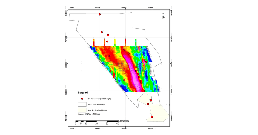
As per the company, the initial renditions of raw (uninterpreted) geophysical data have uncovered the presence of large geophysical anomalies with a 42km by 9km geophysical feature being the most notable. Based on the dimension, the total anomalous extent of the anomaly is 19,904 hectares.
Arcadia believes that these anomalies display features, representing highly conductive aqueous brine pools as indicated by elevated levels of total dissolved solids (TDS).
Few of the interpreted anomalies host similarity to the lithium-rich Eden Pan and Madube Pan. The JORC-compliant lithium in Clay Mineral Resource for Eden Pan has already been defined at 85.2 million tonnes @ 633ppm for 286,909t Li2CO3 (Lithium carbonate equivalent, LCE).
Also, drilling at Madube Pan has intersected lithological units like the Eden Lithium Pan.
As per the company, initial observations established the presence of a closed sub-surface basin, which strengthens the existence of first order geological conditions for the concentration of brines containing lithium.
This type of lithium in brines is mostly connected to ancient, closed basins and arises from the following factors:

(Source: © 2022 Kalkine Media®, date source: company update)
Historical agricultural boreholes indicated geothermal activity and a close relationship between the water quality, TDS and the EM anomaly. As per the company, it may indicate a deep-seated brine deposit within the Bitterwasser half-graben basin.
All the boreholes had a high salinity value (more than 6,000mg/L), however, none of the boreholes have ever been tested for their lithium content.
Interestingly, all the boreholes drilled are coincident with the edge of the most prominent anomaly, presumably focused on the position of the throw of the major lineament making up the half graben. Whereas no information is available of any boreholes drilled within the anomaly.
Arcadia eyes drilling to explore for deep-seated lithium deposits
The next step will include the detailed interpretation of both Electromagnetic (EM) and magnetics data by Arcadia’s consulting geophysicists. It will be aimed at rendering a 3D model of the anomaly to assist with accurate location of drill holes.
Based on these results, a stratigraphic drilling program would also be employed to:
- Confirm the geology in and around the anomaly
- Conduct a drilling campaign for verifying brines’ lithium content.