


Highlights
- LiDAR survey accurately located all the historical workings over the length of the Hargraves and Hill End tenements.
- The data also defines in excellent clarity on the geological structures of the whole area.
- Vertex has started rock chip sampling, targeting the exact locations determined from overlaying the LIDAR on known structures.
Vertex Minerals Limited (ASX:VTX) has provided an upbeat update regarding data obtained from LiDAR survey concerning its Hargraves and Hill End tenements.
In late 2022, the company carried out a thorough LiDAR and aerial photographic survey over the entire Hill End and Hargraves mining and exploration leases. The LiDAR survey accurately located all the historical workings and also defined the geological structures of the whole area with clarity.
The quality of LiDAR data provided clear identification of the location of silica rich rocks (like quartz) protruding from the surrounding ground.
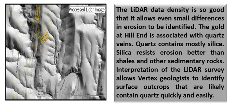
Data and image source: Company update
The information obtained from LiDAR pooled with data collected from previous mining and geological mapping has substantially improved the data set of Vertex used to identify gold bearing targets.
Aiming to derive drill targets, Vertex has kicked off rock chip sampling of the targets on the Mining Lease.
Survey data defines targets for field follow-up program
Vertex expects an improved understanding of mineralisation as well as accurate location data of historical workings on the back of the latest findings, thus enabling efficient prospecting.
The company highlights that the Vertex geology team has gained detailed insight into the extent of mineralisation and prevalence of folded structures within the project. Moreover, the company has got better number of targets for field follow-up assessment for drill priority due to the survey data.

What’s next?
The company aims to target shallow, open pit mineralisation on its Mining Leases. The company is eyeing sufficient mineral resource to justify the refurbishment of the Hill End Processing Plant. The goal is recommencing gold production in an expedited timeframe.
In-depth details of the survey
The Hargraves and Hill End properties were surveyed with LiDAR and 10cm colour RGB aerial photography using RIEGL VQ-780ii sensor. The LiDAR was processed to yield a high resolution 50cm ground DTM. The LiDAR was flown with and minimum average twenty (20) points per square metre with flying height of ~1000 metres to ensure 10cm vertical accuracy.
GeoCloud Analytics was contracted for a detailed interpretation of the data for documenting historical mining evidence and mapping observed structures. The identification and accurate mapping of historical mining activity will be an addition to the present government mines database and would provide correctly geo-locating Vertex’s database of historical maps and sample data.