


GA, UNITED STATES, February 5, 2025 /EINPresswire.com/ -- Understanding how alpine wetlands are degrading is crucial for evaluating the full impact of climate change on these fragile ecosystems. In a significant scientific advancement, researchers have introduced alpine wetlands (AW-CCD)—a pioneering algorithm designed to monitor and characterize the complex, multi-scenario degradation of alpine wetlands using Landsat time series data. This innovative approach overcomes the persistent challenge of cloud cover in high-altitude regions, marking a major leap forward in the long-term monitoring and management of these vital landscapes.
The Qinghai-Tibet Plateau, often referred to as the "Third Pole," has been undergoing dramatic environmental changes. Its alpine wetlands, critical to regional biodiversity and water regulation, are showing alarming signs of stress—declining water resources and meadow degradation among them. Yet, the Plateau’s frequent cloud and snow cover make consistent, long-term monitoring notoriously difficult. Against this backdrop, the urgency for advanced research into how these ecosystems respond to climate change has never been greater.
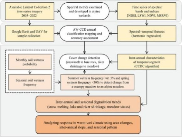
Answering this call, scientists from South China Normal University, Tibet University, and the Chinese Academy of Sciences have developed the alpine wetlands (AW-CCD) algorithm, detailed (DOI: 10.34133/remotesensing.0380) in the January 2, 2025, issue of Journal of Remote Sensing. AW-CCD offers an ingenious solution to the challenge of tracking alpine wetland degradation, especially in the cloud-draped Qinghai-Tibet Plateau. By harnessing Landsat time series data, the framework reliably detects and maps ecosystem changes, effectively filling critical data gaps in high-altitude, cloudy regions.
At the heart of AW-CCD’s innovation is its dual-capability design: it annually classifies wetlands and tracks degradation by integrating long-term inter-annual data with seasonal soil wetness indicators. This refined approach significantly boosts mapping accuracy—improving snow cover detection by 5% and meadow classification by 3%. In the Maidika Wetland, AW-CCD achieved an impressive 94.9% mapping accuracy in 2022. The algorithm’s strength lies in its spectral-temporal analysis, enabling it to capture subtle, multi-scenario surface changes that have long eluded traditional methods struggling with irregular imagery and complex degradation patterns.
The study paints a stark picture of environmental change. Over the past two decades, snow and river areas in the Maidika Wetland shrank by 5.04% and 16.74%, respectively. Meanwhile, 3.23% of swampy meadows transitioned into drier alpine meadows—a shift that signals ecological distress. The most severe degradation occurred before 2009, followed by a brief stabilization until 2015, and a troubling resurgence in recent years. AW-CCD’s use of spectral-temporal index features, such as the Normalized Difference Snow Index (NDSI) for snow detection and the Meadow Spectral Ratio Vegetation Index (MSRVI) for differentiating meadow wetness, has been critical in capturing these nuanced transitions.
The research team employed a comprehensive dataset, analyzing images from Landsat Thematic Mapper (TM), Enhanced Thematic Mapper Plus (ETM+), and Operational Land Imager (OLI) between 2003 and 2022 to cover the entire Maidika Wetland. Cloud and shadow disruptions were minimized using the Fmask algorithm, while elevation and slope data from the Shuttle Radar Topography Mission and ALOS World 3D-30m refined classification precision. Additionally, Global Surface Water data enhanced the accuracy of surface water mapping.
Dr. Yingchun Fu, a leading scientist on the project, emphasized the broader impact of their findings: “The AW-CCD framework not only enhances our capacity to monitor alpine wetlands but also deepens our understanding of how these ecosystems are responding to climate change. This technology could fundamentally reshape conservation efforts in high-altitude regions.” By capturing the intricate, multi-scenario responses of these wetlands, AW-CCD delivers critical insights for preserving the Plateau’s ecological health.
The implications of the AW-CCD framework extend well beyond academic achievement. Its ability to deliver detailed, accurate, and timely data on wetland degradation empowers policymakers and conservationists to make informed decisions. As climate change continues to imperil these sensitive ecosystems, AW-CCD stands out as a transformative tool—one that could help mitigate degradation and safeguard the unique biodiversity of alpine regions. This research not only propels the field of remote sensing forward but also makes a vital contribution to global environmental conservation efforts.
DOI
10.34133/remotesensing.0380
Original Source URL
https://spj.science.org/doi/10.34133/remotesensing.0380
Funding information
This work was supported by the National Natural Science Foundation of China (grant number 42071399), the Second Tibetan Plateau Scientific Expedition and Research, (grant number 2019QZKK060), the Humanities and Social Science Fund of Ministry of Education of China (grant number 23YJAZH019), and the Science and Technology Plan Projects of Tibet Autonomous Region (grant number XZ202301ZY0021G).
Lucy Wang
BioDesign Research
email us here
Legal Disclaimer:
EIN Presswire provides this news content "as is" without warranty of any kind. We do not accept any responsibility or liability for the accuracy, content, images, videos, licenses, completeness, legality, or reliability of the information contained in this article. If you have any complaints or copyright issues related to this article, kindly contact the author above.
![]()